TVS Emerald Altura Map
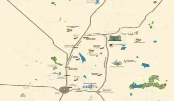
The TVS Emerald Altura Map delivers a precise understanding of the project’s positioning within the evolving North Bangalore landscape. Situated in Bagalur main road Sathanur, this development stands within a zone widely recognized for apartments in Sathanur Bangalore and rising demand driven by infrastructure expansion. The coordinates 13.122° N and 77.633° E allow exact tracking on Google Maps, ensuring buyers can assess the site with clarity and confidence.
Beyond simple navigation, the map reflects how this address connects to the broader North Bangalore real estate investment ecosystem. It outlines surrounding growth corridors, established infrastructure, and the seamless relationship between residential clusters and employment hubs. This level of detail helps buyers move from uncertainty to informed decision-making.
Strategic Location Advantage in North Bangalore
Sathanur continues to gain attention as a high appreciation property in Bangalore, supported by strong infrastructure planning and connectivity. The map highlights the project’s close proximity to arterial roads and emerging urban developments, reinforcing its position within upcoming residential hotspots North Bangalore.
Bellary Road (NH 44), a critical growth spine, plays a major role in shaping the region’s value. Properties near this corridor benefit from direct airport access and proximity to business zones. The TVS Emerald Altura location fits directly into this airport corridor real estate Bangalore advantage, offering both lifestyle comfort and investment strength.
Seamless Connectivity for Daily Travel
Connectivity remains one of the defining strengths of the TVS Emerald Altura Map. The project is positioned within a network that supports efficient movement across the city.
Metro Connectivity
The upcoming metro connected homes North Bangalore advantage becomes evident through Bangalore Metro Phase 3A. This development will strengthen access between North Bangalore and key urban centres, supporting long-term appreciation and everyday convenience.
Road Network
Residents benefit from direct access to major routes that define well-connected apartments in Bangalore North:
- Bellary Road (NH 44)
- Thanisandra Road
- Kogilu Cross
- Jakkur
- Bagalur Road
- Doddaballapura Road
These corridors ensure uninterrupted travel to commercial hubs, making this location ideal for professionals seeking easy commute homes near airport Bangalore.
Public Transport
BMTC services operate consistently in this region, strengthening accessibility for daily travel and supporting future-ready residential projects Bangalore.
Airport Access
Kempegowda International Airport is reachable within 30 minutes, reinforcing the value of projects near NH 44 Bangalore and making this address highly practical for frequent travelers.
Proximity to Major IT Hubs
The map clearly establishes the project’s advantage as an investment flats near Manyata Tech Park destination. Close proximity to employment centres enhances both lifestyle convenience and rental potential.
- Manyata Tech Park – approx. 10.2 km
- Kirloskar Business Park – approx. 12.4 km
- Bagmane Tech Park – approx. 23.4 km
This positioning supports demand from professionals searching for apartments near Manyata Tech Park with good connectivity, making it a strong contender within rental demand areas in North Bangalore.
Access to Essential Social Infrastructure
The TVS Emerald Altura Map also reflects a well-developed social ecosystem, ensuring a balanced lifestyle supported by everyday conveniences.
Educational Institutions
- REVA University – nearby
- Stonehill International School – approx. 10.3 km
- Canadian International School – approx. 5.9 km
These options strengthen the appeal of homes near top schools in North Bangalore.
Healthcare Facilities
- Aster CMI Hospital – approx. 14.8 km
- MS Ramaiah Hospital – approx. 17.5 km
Reliable healthcare access contributes to the value of apartments near healthcare facilities Bangalore.
Shopping & Entertainment
- Bhartiya Mall of Bengaluru – approx. 5.9 km
- Elements Mall – approx. 9.3 km
This ensures access to retail and leisure, aligning with demand for residential projects near malls Bangalore.
Why the TVS Emerald Altura Map Matters for Buyers
A well-detailed map plays a critical role in evaluating a project. The TVS Emerald Altura Map offers insights that go beyond surface-level information, helping buyers understand the real potential of the location.
- Real-time access across major connectivity corridors
- Direct proximity to IT hubs and business districts
- Availability of education, healthcare, and retail infrastructure
- Alignment with real estate growth corridor Bangalore trends
For investors evaluating best property for ROI in Bangalore North, this clarity becomes essential. The map transforms location data into actionable insight, enabling confident decisions.
Conclusion
The TVS Emerald Altura Map serves as a strategic overview of a location positioned for consistent growth. Its integration within future metro connectivity Bangalore North, proximity to employment zones, and access to key infrastructure establish it as a compelling residential choice.
For buyers exploring which is the best location to buy flats in North Bangalore, this project stands out through its connectivity, accessibility, and long-term value. The map presents a clear, factual view of why Sathanur continues to evolve as a preferred residential destination, supported by strong infrastructure and sustained demand.